The first stop was the town of Kirkcudbright (about 2/3 of the way). There was a Scotland visitor center we wanted to stop at for information. As you will see below, it was a good stop. 20 miles past the town was a small Neolithic burial site (near the town of Creetown). Another good stop.
Thursday, August 27, 2015
Part 2: Scotland: Up to Portpatrick
The drive from Keswick to Portpatrick (for some reason, it is one word) was about a 145 miles. We were in no hurry and took in a couple of sites along the way.
The first stop was the town of Kirkcudbright (about 2/3 of the way). There was a Scotland visitor center we wanted to stop at for information. As you will see below, it was a good stop. 20 miles past the town was a small Neolithic burial site (near the town of Creetown). Another good stop.
The map again for reference.
Here we are !
Scottish countryside on the way to our next stop - Portpatrick.
The town of Kirkcudbright.
The marina downtown. It is the only Blue Flag Marina in Scotland. Never heard of that, but it is given to marinas around the world that pass strict criteria for water quality, safety, environmental care, etc.
Looking out at a nice meadow at the edge of town.
Kirkcudbright Parish Church
The town hall had an exhibit from the 2 artist listed just below the painting. Both were from Airdrie, which is about 10 miles east of Glasgow. It must have been a traveling exhibit, because Kirkcudbright is about 100 miles south of Airdrie. They did most of their work in Glasgow.
Paintings in an exhibit hall done by local high school students. I didn't feel right about taking photos by the Airdrie Boys. But, we all liked their work.
More of downtown.
Lunch at the MacLellan's Castle. It was built in the late 1600's. It is a 'tower house,' typical of castles built in Scotland from the mid 1500's to the late 1600's. It is 'L' shaped with one wing running east-west and the other wing running north-south. They meet in the southwest corner. The statue is in memory of those local Scots who were killed in WWI and WWII.
Holy Chambered Cairn, a Neolithic burial site, in Creetown. This is looking from west to east. I mention this because there was a guy there who gave several bystanders a lesson about this site. He was not from Scotland, but had been coming here for 5 years studying the ruins. After a while I couldn't decide if he was really knowledgeable about the ruins or just someone good at story telling. Some of what he said made sense, but that doesn't mean it was right. More on the next photo and third photo down.
This is looking west. As you all know, the sun sets in the west, but not always directly west; sometimes north of west (in summer) and south of west (in winter). The guy said that sun sets directly over the mound in the center of the photo on the first day of spring and the first day of fall. It sets over the tallest part of the mountain (on the left) on the first day of winter and over the center of the clump of trees on the horizon on the right, on the first day of summer.
While I was getting a lesson on the ruins, Tracy and Caroline took a walk up a side road.
Face-on looking south. All I'll say about his speech on this aspect of the ruins is: the sun will shine directly between the 2 tall stones in the center at noon on the first day of spring and fall. He talked about how the stones are angled and other things, but I'm done. The 2 two stones in the center are only about 8' tall.
Our B and B at Portpatrick. It only had 6 rooms. It, along with the town were probably our favorite. We loved the sunroom on the left.
A view from our room overlooking the Irish Sea. On a clear day you can see Ireland, which was only about 20 miles away.
A panorama of Portpatrick.
Caroline, Vajra and I took a side trip here, about 15 miles south of town. Tracy stayed behind and checked out every nook and cranny in Portpatrick.
A view looking west from the parking lot of the visitor center.
The Mull of Galloway nomad.
Someone was nice enough to take our picture.
The Mull of Galloway lighthouse.
A view from the observation deck at the top of the lighthouse. This is looking from inside; the winds were blowing between 45 and 50 MPH and they would not let anyone outside. You can just make out the Isle of Man on the horizon (about 20 miles away).
Looking east; You can see the visitor parking lot.
An old fog horn no longer in use.
A pleasant trail out from the lighthouse.
A nice view.
The low pointy rock to the left is the southern most point in Scotland.
Back in town.
Looking the other way.
The view as we were walking back to our B and B.
Portpatrick has a castle, Dunskey, about 1/2 mile south of town. These small flowers were along the path to the castle.
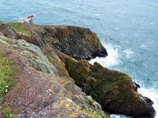
Part of the rocky coast along the way.
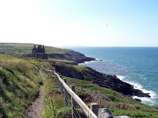
There it is - Dunsky Castle. It was built in the 12th century and has been in ruins since 1684 (if Wikipedia is correct).
Close-up. It's not that big. If you look to the right, a doorway is fenced in. It's normal size.
Another close-up.
A detailed close-up (the red jacket look familiar ?).
Fleta is a world traveler.
Portpatrick from the castle path. The first panorama of the town was taken from the parking lot to the left of the long white building in the background.
The end of the castle walk.
The first stop was the town of Kirkcudbright (about 2/3 of the way). There was a Scotland visitor center we wanted to stop at for information. As you will see below, it was a good stop. 20 miles past the town was a small Neolithic burial site (near the town of Creetown). Another good stop.
Subscribe to:
Post Comments (Atom)


No comments:
Post a Comment