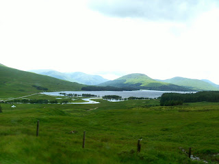
After leaving Portpatrick, we had a 200 mile ride to our next stop, which was a little town called Roy Bridge (named after the 50' bridge that goes over the Roy River; population - not many), about 12 miles NE of Fort William (it is easier to find Fort William - population 10,000).
Before we got to our B and B in Roy Bridge, we stopped off at Fort William. Nearby was a ski lift ride up Aonach Mor, a mountain (4,006' ) just 2 miles to the east of Ben Nevis, the tallest mountain in the UK (4,409')(we thought about climbing it, but after reading the 'fine' print, we decided maybe next time: it was an 8 1/2 mile round trip and took 6 to 8 hours). The ski lift took us to 2,132' From there, there were 2 walking trails on either side of the building where the ski lift stopped.
After leaving Roy Bridge, we decided we just had to see Lock Ness, but to see it, we had to take the long way to our next destination: 110 miles vs. 42. The place we wanted to see, Urquhart Castle (goes back to the 13th century, but is in ruins now), had a gorgeous view of the loch, but was jam-packed with tourists. It was too far to turn around, so just we continued on our way on the long route.
Our next stop was Newtownmore (pop. 982). We spent just one night there before moving on. A mile up the road was a Highland Folk Museum. It was a recreated village from the 1700's.
The map again for reference.
This was on the road along Loch Lomand, another popular tourist spot. Remember, we are driving on the left. Look how close the vegetation is. We could put our arms out the window and touch it. After about 15 miles of this, Vajra said it wore him out and had to have Caroline drive. This was along road A82, which, on the map, looked like it was a 'main' road.
A view along the same road after Loch Lomand (and next 2 photos). I don't know what that type of fence was for, but there were miles of it.
We were surprised to still see snow on some of the mountains.
This was along the same road, but in the Glencoe area.
This photo and all the ones down to the herring gull photo were taken at a skiing area near Fort William. This trail goes to the Sgurr Finnisg-aig (have no clue what it means) viewpoint, elevation 2,175.'
We're at the top, it's cloudy, can't see a thing - so, now what ??
Looking back at the stopping point of our ski lift ride. You can see the clouds moving in. Going...
going...
Gone !!
At the edge, into the abyss if you keep going ?
Saved by the clouds burning off ! Same view and a long way down if you were clumsy.
Panorama of the valley.
What a view.
They are definitely pleased the clouds are gone.
On our way to the next viewpoint - Meall Beag (no clue what that means, either) at 2,060.'
Looking back at the other viewpoint.
A family portrait.
The Nevis Range nomad.
Reminded me of a hyacinth.
I forget how many miles of mountain bike trails there were just in that area.
Not quite enough snow yet.
But enough to create this small runoff stream.
A juvenile herring gull in a distillery parking lot back in Fort William.
Shopping area in Fort William. The town was not laid out in a way that was good for taking photos.
Our B and B in Roy Bridge - Homagen B and B.
Back on the road again. This is the beginning of Loch Ness. This was in the town of Ft. Augustus, at the SW end of the loch.
Loch Ness looking NE.
Loch Ness looking SW. No sign of Nessy in either photo. What gives ??
Our B and B in Newtownmore - the Glen Hotel.
Looking up the main st.
Highland Folk Museum.
A typical home - mud and thatch.
One of the rooms.
Rather smoky inside. There is no chimney, just a hole in the roof above the fire.
The lady on the right is dressed in period clothes.
More of the village.
They made their own cloth on this type of loom.
This and the next photo were along the trail down to the village. Both were about 4' tall.
As cute as can be !
Didn't think to ask why this was on the property. I guess they are older than we think !!
The view beyond the 'village.'


No comments:
Post a Comment